
Thoughts from Episode 14: Location, location, location
Thanks to a bright idea from Suiren, Sara and Tsuwabuki are sent off on a months-long expedition to get regional governors to release their hoarded rice. It turns out their strategy is to dazzle the governors with a performance based on the legend of Yamato Takeru, before pulling out their swords and threatening them.
One night later in the trip, Shikibu-kyo no Miya is awaiting the two of them. He flirts aggressively with Sara, leading Tsuwabuki to step in to take one for the team, but just as things start to heat up, Sara returns the favour and saves Tsuwabuki from an inevitable gay awakening. Sara tells Tsuwabuki he’s a great friend he never should’ve doubted, but when he returns to Heian-kyo just after Shi no Hime gives birth, he realises his newborn daughter looks a lot like his loyal buddy.
There’s a lot that could be said about this chapter, but the thing I want to focus on today is locations! After a long period where nearly all the action takes place in the capital, Episodes 13 and 14 both see the protagonists go further afield. In Episode 13, they visit Yoshino, and in this chapter, Sara and Tsuwabuki travel around quite a bit.
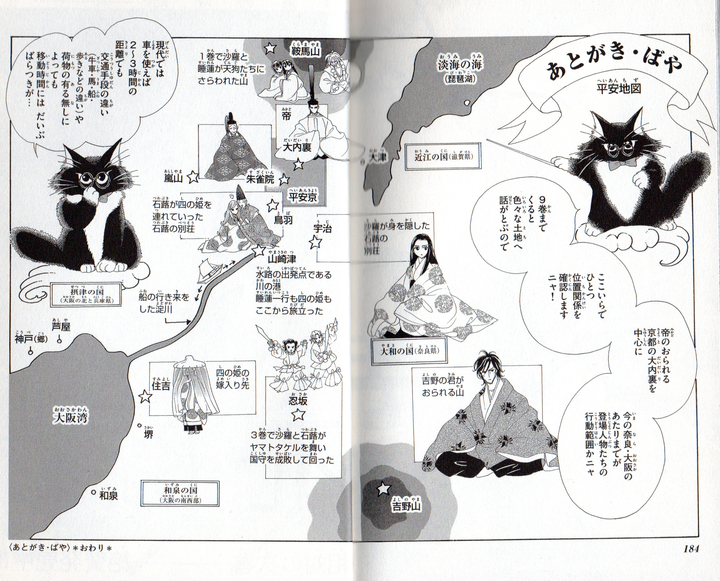
Map from volume 9, pages 184 and 185.
©Chiho Saito/Shogakukan
The only named place they visit in Episode 14 is Osaka – that’s 忍坂 with a short “o”, not the more famous 大阪 with a long “o”. The place that appears in Torikae baya is in modern-day Nara Prefecture, whereas the big city of Osaka we know today didn’t exist with that name until a few hundred years later. Incidentally, another more famous “Osaka” in the Heian period was 逢坂 (also a long “o”), an important barrier on the route from Heian-kyo to the eastern provinces, which appears in a number of poems.
Now, as you may have gleaned from my previous post where I talked about checking out locations from the manga in person, places in Torikae baya are often portrayed in quite specific detail. Places like palace buildings are clearly drawn based on real-life counterparts, and Saito uses some of the afterwords in each volume to provide plans of Heian-kyo and the palace. For the latter, she points out that she made a few adjustments to the exact layout compared with what the real Heian court was like, but just having it drawn up is really helpful for understanding how everything comes together.
One afterword also features a map of the whole relevant area, showing locations like Kurama and Yoshino – and since it’s in volume 9, there are also other places from much later in the story. A nice thing about this map is that Saito gives a little explanation of how people got around the area and how long it took. Typical means of transport included boat, horse, ox-drawn cart or walking, and even using the fastest of these, a trip that would take a few hours today might have required a day’s travel or more at the time of Torikae baya.
A couple of months ago, I added the Extras page as a place for the series timeline (which is still getting semi-regular updates!), and now I’ve added a map there too. You can then click through to a Google map where you can see where these historical locations line up with modern-day geography. I’ve tried to include all specified locations from the manga, but as there are probably some later ones that I can’t remember right now, you might see some updates to this as well. Please check it out!